How Do You Feel About The Ways Chain Restrictions Are Communicated To Drivers?
Topic 32159 | Page 3
Aggregated information in one source would be helpful. PackRat mentioned being able to access the information needed from one source or another, but I think we could be more efficient in those moments if we had a source to turn to that compiled the information and had multiple means of dissemination. Thinking about like a weather band broadcast that has more inclusive information. Live streaming sources with updates. Information put out over CB. Hopefully I making this idea clear, but it's basically gathering all of the available information on a particular weather, traffic, emergency event, etc and then going through the information to find the most accurate reports. Once aggregated, it is then disseminated to drivers and dispatchers through the means that I mentioned. This would obviously require a team of highly trained people with significant resources.
Thanks for this, Ryan! Super well-thought-out.
Once again, this is great food for thought. And, as you mention, implementing an ideal this intricate would take a lot! That said, it's good to establish "the ideal 'moonshot'" situation and go from there. :-)
Dispatcher:
Dispatcher, Fleet Manager, Driver Manager
The primary person a driver communicates with at his/her company. A dispatcher can play many roles, depending on the company's structure. Dispatchers may assign freight, file requests for home time, relay messages between the driver and management, inform customer service of any delays, change appointment times, and report information to the load planners.HOS:
Hours Of Service
HOS refers to the logbook hours of service regulations.
Aggregated information in one source would be helpful. PackRat mentioned being able to access the information needed from one source or another, but I think we could be more efficient in those moments if we had a source to turn to that compiled the information and had multiple means of dissemination. Thinking about like a weather band broadcast that has more inclusive information. Live streaming sources with updates. Information put out over CB. Hopefully I making this idea clear, but it's basically gathering all of the available information on a particular weather, traffic, emergency event, etc and then going through the information to find the most accurate reports. Once aggregated, it is then disseminated to drivers and dispatchers through the means that I mentioned. This would obviously require a team of highly trained people with significant resources.
Thanks for this, Ryan! Super well-thought-out.
Once again, this is great food for thought. And, a s you mention, implementing an ideal this intricate would take a lot! That said, it's good to establish "the ideal 'moonshot'" situation and go from there. :-)
Indeed!! Well said, all y'all.
Super glad Ryan joined us, with his wit & wisdom. Always great to have some 'good hands' (new to US!) up in here!
Thanks, for sure ~
~ Anne ~
ps: I sure hollered to Brett about the photo conundrums, assumedly fixed; but I still can't share the 511, sorry!
Look (again) in my gallery, and once more, in that of IDMtnGal. If you care to!!
Dispatcher:
Dispatcher, Fleet Manager, Driver Manager
The primary person a driver communicates with at his/her company. A dispatcher can play many roles, depending on the company's structure. Dispatchers may assign freight, file requests for home time, relay messages between the driver and management, inform customer service of any delays, change appointment times, and report information to the load planners.Dm:
Dispatcher, Fleet Manager, Driver Manager
The primary person a driver communicates with at his/her company. A dispatcher can play many roles, depending on the company's structure. Dispatchers may assign freight, file requests for home time, relay messages between the driver and management, inform customer service of any delays, change appointment times, and report information to the load planners.HOS:
Hours Of Service
HOS refers to the logbook hours of service regulations.This. For me, I assume and prepare for the worst, and either park it or get pleasantly surprised about the road conditions. I was taught to carry chains for the most restrictive state compliance, and you're golden as far as having proper devices.
The issue I see with what you are speaking about, is very rarely do startup apps have live real time data, or correct data minute by minute.
If I am doing my job correctly, I know roughly what weather is in my path, and where it's likely to affect me on my route. I also have sufficient notification, via lighted signs.
The general motoring public aren't reading the signs nearly to the extent that a professional driver does (or should be doing.) It seems like you are attempting to reinvent the wheel.
I rely on myself to find out the necessary data that I may utilize each day concerning weather and road conditions. Every western state has apps concerning road construction, weather, and obstacles. The final decision to drive or not rests with each driver. The only thing that would surprise me would be snow in July or August. I've seen it every other month.
This. For me, I assume and prepare for the worst, and either park it or get pleasantly surprised about the road conditions. I was taught to carry chains for the most restrictive state compliance, and you're golden as far as having proper devices.
The issue I see with what you are speaking about, is very rarely do startup apps have live real time data, or correct data minute by minute.
If I am doing my job correctly, I know roughly what weather is in my path, and where it's likely to affect me on my route. I also have sufficient notification, via lighted signs.
The general motoring public aren't reading the signs nearly to the extent that a professional driver does (or should be doing.) It seems like you are attempting to reinvent the wheel.
I rely on myself to find out the necessary data that I may utilize each day concerning weather and road conditions. Every western state has apps concerning road construction, weather, and obstacles. The final decision to drive or not rests with each driver. The only thing that would surprise me would be snow in July or August. I've seen it every other month.
You are absolutely correct that apps don't have the best information that is to-the-minute accurate. That's why it would be great if there were a way to distribute currently relevant information quickly, accurately, and efficiently. Just as Rainey pointed out, signs may not be updated to reflect current conditions.
I have to say that one issue that likely stands in the way is the need to profit off of something that should be a public service. I don't want to get too much into that because I am straying from the context of your comment, NaeNaeInNC.

Aggregated information in one source would be helpful. PackRat mentioned being able to access the information needed from one source or another, but I think we could be more efficient in those moments if we had a source to turn to that compiled the information and had multiple means of dissemination. Thinking about like a weather band broadcast that has more inclusive information. Live streaming sources with updates. Information put out over CB. Hopefully I making this idea clear, but it's basically gathering all of the available information on a particular weather, traffic, emergency event, etc and then going through the information to find the most accurate reports. Once aggregated, it is then disseminated to drivers and dispatchers through the means that I mentioned. This would obviously require a team of highly trained people with significant resources.
Thanks for this, Ryan! Super well-thought-out.
Once again, this is great food for thought. And, a s you mention, implementing an ideal this intricate would take a lot! That said, it's good to establish "the ideal 'moonshot'" situation and go from there. :-)
Indeed!! Well said, all y'all.
Super glad Ryan joined us, with his wit & wisdom. Always great to have some 'good hands' (new to US!) up in here!
Thanks, for sure ~
~ Anne ~
ps: I sure hollered to Brett about the photo conundrums, assumedly fixed; but I still can't share the 511, sorry!
Look (again) in my gallery, and once more, in that of IDMtnGal. If you care to!!
Thanks, Anne! I was able to check out more pages of your photos, and I DID find the screenshot of all the 511 apps! (Thanks for fixing that image-page-navigation issue, Brett.) It's a really good illustration of why all-in-one solutions might be very welcome... yet are pretty darn difficult to execute, hehe. I'm glad downloading multiple apps is a viable option, though! I'm 100% a proponent of ANYthing that helps keep everyone safe out there.
Additionally, I fully hear / respect anyone that's a bit skeptical of an app trying to solve a problem like this! Plenty of 'em (apps) will come and go without really solving anything... especially if financial gain is the sole (and soulless!) motivation (...just to briefly address your last point there, Ryan).
And, as we're all aware, not all problems can be solved by merely throwing tech at the issue. Of course, knowing what specific challenges exist and what current solutions are in place (no matter how cleverly & uniquely improvised) is crucial to any progress! But, your point about personal responsibility and preparedness is really, really well made, NaeNaeInNC. :-) THAT is something for which no amount of technology can directly account!
Dispatcher:
Dispatcher, Fleet Manager, Driver Manager
The primary person a driver communicates with at his/her company. A dispatcher can play many roles, depending on the company's structure. Dispatchers may assign freight, file requests for home time, relay messages between the driver and management, inform customer service of any delays, change appointment times, and report information to the load planners.Dm:
Dispatcher, Fleet Manager, Driver Manager
The primary person a driver communicates with at his/her company. A dispatcher can play many roles, depending on the company's structure. Dispatchers may assign freight, file requests for home time, relay messages between the driver and management, inform customer service of any delays, change appointment times, and report information to the load planners.HOS:
Hours Of Service
HOS refers to the logbook hours of service regulations.OWI:
Operating While Intoxicated
Alex,
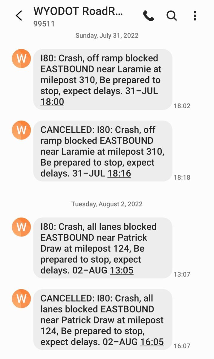
Besides the page of apps that you saw in Ann's pictures, I also get text messages from WYODOT. You have to sign up on an actual computer/laptop and you can pick any roads in the state of Wyoming to get reports on. I get reports for I-80, US 30 and US 287 from Laramie down to the border with Colorado. They are the same as the overhead signs and they do get updated fairly quickly.
It's pretty quiet through summer. Winter time with storm warnings, I can get upwards of 100 a day.
DOT:
Department Of Transportation
A department of the federal executive branch responsible for the national highways and for railroad and airline safety. It also manages Amtrak, the national railroad system, and the Coast Guard.
State and Federal DOT Officers are responsible for commercial vehicle enforcement. "The truck police" you could call them.
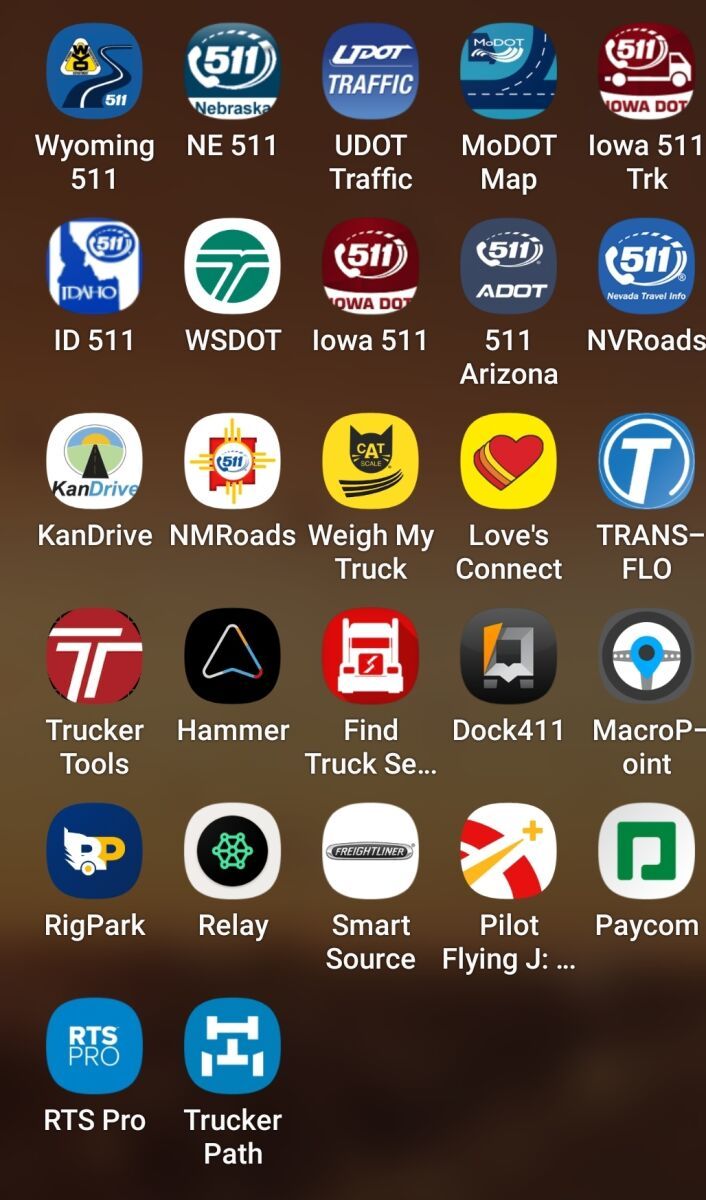
It finally allowed me to download my updated version of trucking apps.
Laura

Alex,
Besides the page of apps that you saw in Ann's pictures, I also get text messages from WYODOT. You have to sign up on an actual computer/laptop and you can pick any roads in the state of Wyoming to get reports on. I get reports for I-80, US 30 and US 287 from Laramie down to the border with Colorado. They are the same as the overhead signs and they do get updated fairly quickly.
It's pretty quiet through summer. Winter time with storm warnings, I can get upwards of 100 a day.
Hi, Laura (a.k.a. IDMtnGal)!
Thanks so much for sharing both of these posts / screenshots. :-) Lots of interesting insight here. You touch on a lot of points with regards to user sign-up experience, how targeted notifications can / should be, general complexity, and - at least in your experience - the possibility that accurate and up-to-date information can be disseminated.
I really appreciate how you took the bull by its proverbial horns and curated your own set of tools!
It sounds like the I-80, US 30, and US 287 from Laramie to CO's border notifications are pretty targeted for you. Just curious - when you say you can get 100+ notifications for that neck of the woods during winter weather, do you generally find that abundance of info to be helpful, or would you say it can get to a point of "information overload"? No doubt, winter weather makes for LOTS of "activity" in that area, hehe.
DOT:
Department Of Transportation
A department of the federal executive branch responsible for the national highways and for railroad and airline safety. It also manages Amtrak, the national railroad system, and the Coast Guard.
State and Federal DOT Officers are responsible for commercial vehicle enforcement. "The truck police" you could call them.
Dm:
Dispatcher, Fleet Manager, Driver Manager
The primary person a driver communicates with at his/her company. A dispatcher can play many roles, depending on the company's structure. Dispatchers may assign freight, file requests for home time, relay messages between the driver and management, inform customer service of any delays, change appointment times, and report information to the load planners.Indeed!!!
Better trained drivers.
More legal truck parking locations within 100 miles of metropolitan areas.
New Reply:
New! Check out our help videos for a better understanding of our forum features


Preview:
This topic has the following tags:
Adverse Conditions Advice For New Truck Drivers Driver Responsibilities Winter Driving Tips



 TT On Facebook
Aggregated information in one source would be helpful. PackRat mentioned being able to access the information needed from one source or another, but I think we could be more efficient in those moments if we had a source to turn to that compiled the information and had multiple means of dissemination. Thinking about like a weather band broadcast that has more inclusive information. Live streaming sources with updates. Information put out over CB. Hopefully I making this idea clear, but it's basically gathering all of the available information on a particular weather, traffic, emergency event, etc and then going through the information to find the most accurate reports. Once aggregated, it is then disseminated to drivers and dispatchers through the means that I mentioned. This would obviously require a team of highly trained people with significant resources.
Dispatcher:
Dispatcher, Fleet Manager, Driver Manager
The primary person a driver communicates with at his/her company. A dispatcher can play many roles, depending on the company's structure. Dispatchers may assign freight, file requests for home time, relay messages between the driver and management, inform customer service of any delays, change appointment times, and report information to the load planners.HOS:
Hours Of Service
HOS refers to the logbook hours of service regulations.