I-15 Southbound Delays Coming Into California - FYI
Topic 32262 | Page 1

Thanks for the information, I will try to figure it out for more. Keep sharing such informative post.
Thanks for the information, I will try to figure it out for more. Keep sharing such informative post.
Hi, William, welcome to Trucking Truth!
Are you a current CDLA driver, out the California way?? Please introduce yourself! :)
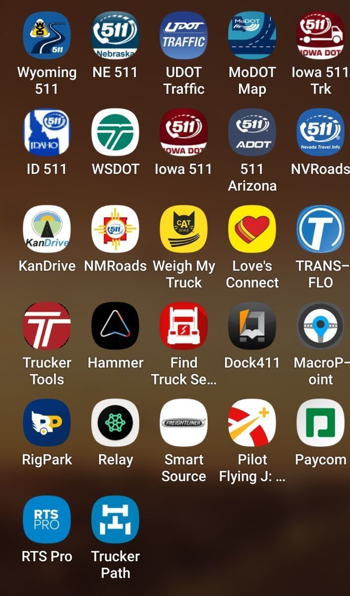
Also, here's Laura's (IDMtnGal) phone apps, for traffic out Mid/West:

Just a head's up, check out conditions before getting stuck in a long delay. Our son Michael shared that the roadway signs warned of a delay ahead due to I-15 reduced to one lane because of road damage from flooding but the warning didn't give any idea of the length of the delay or suggest alternative routes. He later heard on the CB from some northbound drivers that some of the southbound drivers that had made it through reported it took them 5 hours to make it through. He didn't have enough time on his clock for such a delay so he turned around and took 95 north and then 160 west. Spending the night in Pahrump.
Harvey; does Michael (and/or even yourself,) use Caltrans? CalTrans/Popular Travel Links, Maps, Roads, etc:
That middle column after the header has some cool stuff, cameras, etc; similar to our: OHGO App.
When Tom was OTR , I'd often 'look ahead' for him, on the PC, and warn him before the CB's would, haha! Fun times ~ Sometimes in the winter, I'll watch the Ohio cameras, and see his truck roll on by, haha!
Be safe, all ~
~ Anne ~
CDL:
Commercial Driver's License (CDL)
A CDL is required to drive any of the following vehicles:
- Any combination of vehicles with a gross combined weight rating (GCWR) of 26,001 or more pounds, providing the gross vehicle weight rating (GVWR) of the vehicle being towed is in excess of 10,000 pounds.
- Any single vehicle with a GVWR of 26,001 or more pounds, or any such vehicle towing another not in excess of 10,000 pounds.
- Any vehicle, regardless of size, designed to transport 16 or more persons, including the driver.
- Any vehicle required by federal regulations to be placarded while transporting hazardous materials.
OTR:
Over The Road
OTR driving normally means you'll be hauling freight to various customers throughout your company's hauling region. It often entails being gone from home for two to three weeks at a time.
DOT:
Department Of Transportation
A department of the federal executive branch responsible for the national highways and for railroad and airline safety. It also manages Amtrak, the national railroad system, and the Coast Guard.
State and Federal DOT Officers are responsible for commercial vehicle enforcement. "The truck police" you could call them.
Dm:
Dispatcher, Fleet Manager, Driver Manager
The primary person a driver communicates with at his/her company. A dispatcher can play many roles, depending on the company's structure. Dispatchers may assign freight, file requests for home time, relay messages between the driver and management, inform customer service of any delays, change appointment times, and report information to the load planners.
Thanks for the information, I will try to figure it out for more. Keep sharing such informative post.
Harvey; does Michael (and/or even yourself,) use Caltrans? CalTrans/Popular Travel Links, Maps, Roads, etc:
That middle column after the header has some cool stuff, cameras, etc; similar to our: OHGO App.
When Tom was OTR , I'd often 'look ahead' for him, on the PC, and warn him before the CB's would, haha! Fun times ~ Sometimes in the winter, I'll watch the Ohio cameras, and see his truck roll on by, haha!
Be safe, all ~
~ Anne ~
Yes, we use CalTrans QuickMap apps very often but, such as in this case, they often don't give any estimate of the delay. 20 minutes would be okay but not 5 hours. QuickMaps also recently introduced a feature to send a use push notifications of events in your area (requres activating and allowing use of your location). Last week our local bridge got stuck when trying to raise for a ship coming out of Sacramento. CalTrans issued a sig alert and notice on QuickMaps but didn't think a hard closure was necessary even though it was obviously going to take a long time to get fixed (about six hours this time). Many cars turned around but nowhere for trucks to turn around.
If CalTrans was issuing a warning of the lengthy delay, I would not have posted. Usually they are pretty good about it but sometimes fail.
OTR:
Over The Road
OTR driving normally means you'll be hauling freight to various customers throughout your company's hauling region. It often entails being gone from home for two to three weeks at a time.
DOT:
Department Of Transportation
A department of the federal executive branch responsible for the national highways and for railroad and airline safety. It also manages Amtrak, the national railroad system, and the Coast Guard.
State and Federal DOT Officers are responsible for commercial vehicle enforcement. "The truck police" you could call them.
OWI:
Operating While Intoxicated
Any idea where? I don’t see it on the app. If still on going, hopefully it will be fixed before everyone returns from Vegas to Cali on Sunday And Monday.
Any idea where? I don’t see it on the app. If still on going, hopefully it will be fixed before everyone returns from Vegas to Cali on Sunday And Monday.
Not sure exactly what the road status is now as it is not showing up on QuickMaps but apparently they have suspended repairs over the holiday weekend. See this article
I had noticed yesterday that Michael had turned around yesterday (I use Life360 app sometimes to see what he's up to) and it did show up on QucikMaps then but lacked specifics. He called last night and I asked him about it and he shared how he had heard of the very long delays on his CB.
OWI:
Operating While Intoxicated
It’s a bridge down by Nipton, so approximately 45 miles south of Vegas. Good news, though, all lanes are supposed to be open by this weekend. https://www.ktnv.com/traffic/temporary-repairs-should-keep-southbound-i-15-lanes-open-over-labor-day-weekend?fs=e&s=cl
Hay, driver pals, etc:
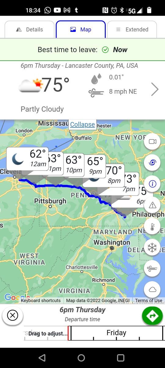
Here's this; seems pretty cool but I haven't installed it yet . . . anyone wanna go first and advise? I'm not driving, so won't mean much to me .. (YET!)
I'm packing my 'mental' bags, always!
~ Anne ~

Hay, driver pals, etc:
Here's this; seems pretty cool but I haven't installed it yet . . . anyone wanna go first and advise? I'm not driving, so won't mean much to me .. (YET!)
I'm packing my 'mental' bags, always!
~ Anne ~
Here you go. It's not bad, but I don't trust the routing to be reliable safe-for-trucks routes. It's a good tool to get an idea of weather expected along one's route. I think where it finds its biggest limitation is that along a route, a specific road might be closed. If the app isn't in sync with the truck route being run, then the app ceases to be helpful.
Ex: I was running I-81 last week when there was a torrential rain that led to flash flooding. Part of I-81 got washed out and the interstate was closed. If I were using this app and it doesn't have me taking the exact route that I am, then it may not provide me with information on this particular section of an interstate having an issue. I just happened to decide to pull off the interstate to take a 30 at a truck stop nearby and saw PA state troopers blocking off the entrance to the interstate as I was driving to the truck stop from the highway.
Myself, I will use this app, especially during the winter, in order to get an idea of what route may help me avoid winter weather.

Interstate:
Commercial trade, business, movement of goods or money, or transportation from one state to another, regulated by the Federal Department Of Transportation (DOT).
New Reply:
New! Check out our help videos for a better understanding of our forum features


Preview:


 TT On Facebook
Just a head's up, check out conditions before getting stuck in a long delay. Our son Michael shared that the roadway signs warned of a delay ahead due to I-15 reduced to one lane because of road damage from flooding but the warning didn't give any idea of the length of the delay or suggest alternative routes. He later heard on the CB from some northbound drivers that some of the southbound drivers that had made it through reported it took them 5 hours to make it through. He didn't have enough time on his clock for such a delay so he turned around and took 95 north and then 160 west. Spending the night in Pahrump.