The Importance Of Pre-planning!
Topic 32710 | Page 1

Wise words Etch.
We have preached the exact same approach to trip-planning on this forum, countless times, for many years... excellent, first-hand advice. No matter how many times it's said...there are always the non-believers. Those who roll the dice and do not cover details like you described above.
Thank you for taking the time to post this.
HOS:
Hours Of Service
HOS refers to the logbook hours of service regulations.Driving local, I use google satellite maps and the Hammer truck gps app all the time to trip plan since I’m going to new places and peoples houses quite often. I have an atlas but it doesn’t scale down/zoom in enough for most of where I need to go. I search the address, look at the suggested routes and then create my own truck friendly trip plan off of them. As you all know google likes to cut you through neighborhoods and back roads for the quickest route. I drive down the road telling the gps no for the majority of the turns it wants me to take.

Relying on GPS alone will put a driver in all sorts of troublesome situations from low clearance issues, weight restricted roads, truck restricted roads, tight turns a truck can't make, narrow roads not suitable for a truck, and likely other issues that escape my mind as I type this.
Valid point. Always good practice not to rely on a single resource for trip planning. A few years ago I was on a road trip in my car traveling through Wyoming following my GPS when I found myself on a dirt road rolling through some farmer's property. I eventually made it back to the pavement without getting into trouble.
It was hard for me to get used to using GPS in trucking. But over the last eight months, I've learned its idiosyncratic tendencies and when to ignore some of the suggestions it provides. During pretrip I always write down the final turns to my shipper/receiver from major roads on my dry-erase board and keep that in plain sight. The most valuable feature of the GPS is time estimation followed by real-time traffic information. One example is a time when route 80E was shut down because of an accident. I was alerted by my GPS and able to exit just before the backup on the highway that lasted over 4 hours. But I only take the reroute if I'm familiar with it or have the opportunity to pull over and assess the reroute.
Shipper:
The customer who is shipping the freight. This is where the driver will pick up a load and then deliver it to the receiver or consignee.
OWI:
Operating While Intoxicated
Just to be clear, I do not follow the GPS blindly. I use the combination of maps and suggested routes to find my way by staying on the major arteries as much as possible and limiting the amount of turns that need to be made.
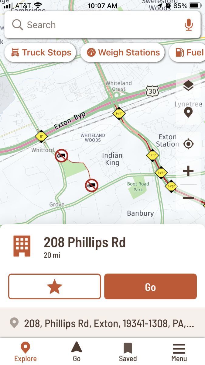
The Hammer app is good for avoiding low clearances but not all truck restricted roads show up on it so as always, keep your eye on the road signs. Here is a screen shot for anyone not familiar with the Hammer GPS app showing both clearance heights and restricted roads.

OWI:
Operating While Intoxicated
A lot of drivers recommend that app and report good things about it. The first three times I used the Hammer app it tried to send me down truck-restricted roads. Once in Green Bay. Once in Chicago. Once in Toledo. I abandoned the app months ago.
Just to be clear, I do not follow the GPS blindly. I use the combination of maps and suggested routes to find my way by staying on the major arteries as much as possible and limiting the amount of turns that need to be made.
The Hammer app is good for avoiding low clearances but not all truck restricted roads show up on it so as always, keep your eye on the road signs. Here is a screen shot for anyone not familiar with the Hammer GPS app showing both clearance heights and restricted roads.
OWI:
Operating While Intoxicated
it tried to send me down truck-restricted roads
Running local P&D , and still learning all our customer locations, I’m short trip planning multiple times a day. I bounce around the same town/area one day, the next day I’m in a different area. After I’ve run an area once or twice, I’ll remember how to get around to our main customers but other random stops always pop up. Hammer has failed me as well! Now I mainly use it to check for the low clearances, there are many in the Philly/south Jersey, Delaware area we service. Like I said above, I compare the suggested routes from Hammer and Google, then study the surrounding map and usually create my my own route to stay on the major roads. I exit the Hammer app and leave google on, it reroutes me as I ignore turns until it finally lines up with my predetermined route. Sometimes they both give the same route and I’ll agree it is the safest, best way but not to often
P&D:
Pickup & Delivery
Local drivers that stay around their area, usually within 100 mile radius of a terminal, picking up and delivering loads.
LTL (Less Than Truckload) carriers for instance will have Linehaul drivers and P&D drivers. The P&D drivers will deliver loads locally from the terminal and pick up loads returning to the terminal. Linehaul drivers will then run truckloads from terminal to terminal.
TWIC:
Transportation Worker Identification Credential
Truck drivers who regularly pick up from or deliver to the shipping ports will often be required to carry a TWIC card.
Your TWIC is a tamper-resistant biometric card which acts as both your identification in secure areas, as well as an indicator of you having passed the necessary security clearance. TWIC cards are valid for five years. The issuance of TWIC cards is overseen by the Transportation Security Administration and the Department of Homeland Security.

A lot of drivers recommend that app and report good things about it. The first three times I used the Hammer app it tried to send me down truck-restricted roads. Once in Green Bay. Once in Chicago. Once in Toledo. I abandoned the app months ago.
Just to be clear, I do not follow the GPS blindly. I use the combination of maps and suggested routes to find my way by staying on the major arteries as much as possible and limiting the amount of turns that need to be made.
The Hammer app is good for avoiding low clearances but not all truck restricted roads show up on it so as always, keep your eye on the road signs. Here is a screen shot for anyone not familiar with the Hammer GPS app showing both clearance heights and restricted roads.
I ditched it when it kept trying to route me around I-76 in PA, showing a low clearance issue on I-76.
OWI:
Operating While Intoxicated
I've apologetically ruined many drivers vacations asking for specific directions on how to get a customer.
New Reply:
New! Check out our help videos for a better understanding of our forum features


Preview:


 TT On Facebook
So I got a story for those who think relying solely on your gps is ok. I’m a week into my TNT training and so far I’ve had two loads that have taken me across the Appalachians. Both times it’s been at night and both times it’s been raining. Also both times the gps will do a recalculation and tell me to take an exit onto a state highway while up in the mountains. Now I’m pretty familiar with these mountains having spent many years riding them on my Harley. Because of that I know what the state highways are like- awesome for bikes, not so much for semi’s. Having that knowledge is what allowed me to tell the gps to pound sand and I stayed on the interstate.
Now imagine someone who didn’t have that knowledge of the area. That $400 piece of technology would have put someone in a bad spot really quick. This is why I feel it is so vitally important to become familiar with the road atlas. A 10 minute check of the route in the atlas can prevent a lot of heartache and potential disaster later on. A gps is great and can be very helpful for so many things, but nothing will ever replace old school map reading.
Along with that, what will happen when you lose signal and the gps goes out? Or how about hitting one of those 5 foot deep pot holes in W. Virginia and your gps bounces to the floor and breaks? To those in training now- become familiar with that atlas. Even if they don’t teach it as part of your training. Take the initiative to learn it on your own. Don’t be the one to believe that all this technology will never let you down. All it takes is that one time the gps leads you off course and something catastrophic happens.
Interstate:
Commercial trade, business, movement of goods or money, or transportation from one state to another, regulated by the Federal Department Of Transportation (DOT).
HOS:
Hours Of Service
HOS refers to the logbook hours of service regulations.TNT:
Trainer-N-Trainee
Prime Inc has their own CDL training program and it's divided into two phases - PSD and TNT.
The PSD (Prime Student Driver) phase is where you'll get your permit and then go on the road for 10,000 miles with a trainer. When you come back you'll get your CDL license and enter the TNT phase.
The TNT phase is the second phase of training where you'll go on the road with an experienced driver for 30,000 miles of team driving. You'll receive 14¢ per mile ($700 per week guaranteed) during this phase. Once you're finished with TNT training you will be assigned a truck to run solo.