A Question About Navigation Once You're Off The Highway
Topic 33272 | Page 1
Scott, my Qualcomm navigation will only give me turn by turn directions if a destination is entered. Doesn’t have to include a street address. It can just be a city or town.
So, I always enter a destination before I leave a pick up or a delivery. Only then do I get turn by turn directions and a map on the screen.
Qualcomm:
Omnitracs (a.k.a. Qualcomm) is a satellite-based messaging system with built-in GPS capabilities built by Qualcomm. It has a small computer screen and keyboard and is tied into the truck’s computer. It allows trucking companies to track where the driver is at, monitor the truck, and send and receive messages with the driver – similar to email.Truck gps systems have gotten way better since then. I wasn’t even driving back then but they’ve even improved significantly since I started back in 2015. As someone who’s done a lot of local driving and am currently mostly local I’m also a huge proponent of using all the tools available to you so I also use Google maps to give me a better idea if something is a good route if I’m not sure. I use the main traffic view to give me an idea which routes are probably truck routes (bigger roads are better generally speaking obviously) and I’ll use satellite view to look for things like bridges and train tracks. Most of the time just regular overpasses won’t have a super low clearance but overpasses with train tracks tend to have low clearances below.
Here’s an example of what I look for:
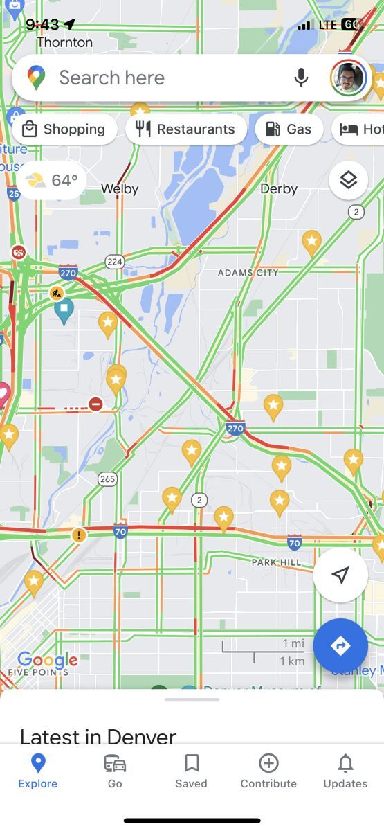
This is a snippet of an area of Denver I tend to drive in quite a bit (the stars are some of the places I’ve been to in a truck). You can clearly see which roads are more main roads because of the way Google color codes them. Not all of them are truck routes but you generally want to avoid the small white roads.
This is another view from that same area with satellite view zoomed way in:
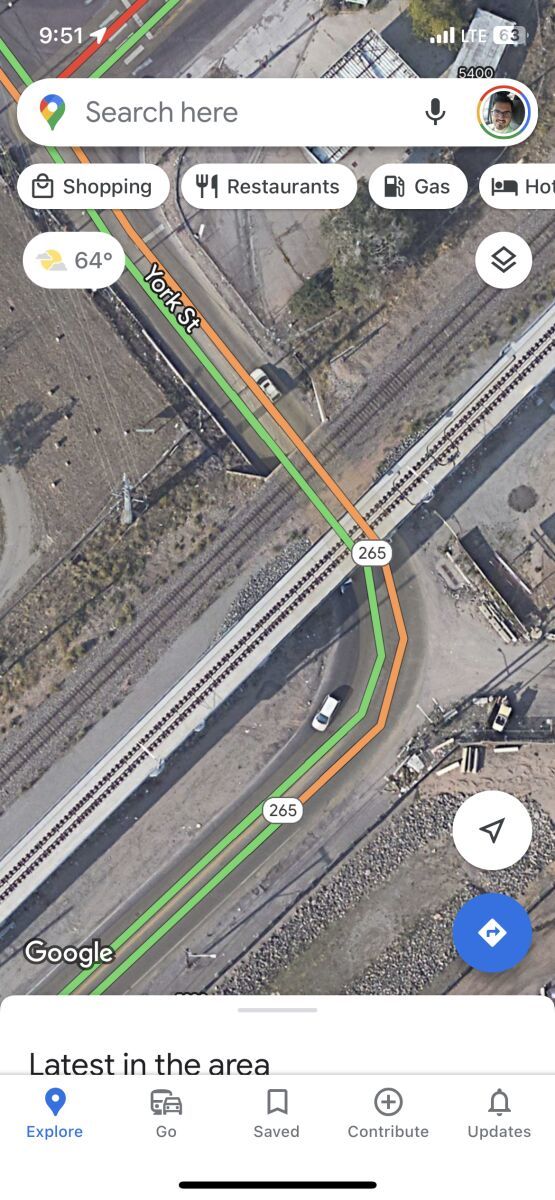
This is a low bridge I have to go around in the area. If you look closely you can see the train tracks go OVER the road. In this particular case the bridge underneath is only about 11 feet high or so. Train tracks don’t necessarily mean you’re gonna have a low bridge situation but it’s something I tend to look out for if I have to drive through an unknown area.
Like I said though, truck gps’s these days are generally pretty fantastic. I personally am a bit wary of trusting one too much for local driving so I have one but pretty much never use it. Even when I do regional runs I don’t really use my truck gps all that much. Idk why
Regional:
Regional Route
Usually refers to a driver hauling freight within one particular region of the country. You might be in the "Southeast Regional Division" or "Midwest Regional". Regional route drivers often get home on the weekends which is one of the main appeals for this type of route.
Over The Road:
Over The Road
OTR driving normally means you'll be hauling freight to various customers throughout your company's hauling region. It often entails being gone from home for two to three weeks at a time.
I wouldn't trust Google maps for truck navigation completely. I pull a 5th wheel rv trailer that is also 13'6" and unless I know the route for sure I might believe the Rand McNally Truckers road atlas or a trucker that has travelled a certain route but google maps is generally designed for 4 wheeler directions. I wouldn't want to leave my 2 a/c units on the side of the road.
I wouldn't trust Google maps for truck navigation completely. I pull a 5th wheel rv trailer that is also 13'6" and unless I know the route for sure I might believe the Rand McNally Truckers road atlas or a trucker that has travelled a certain route but google maps is generally designed for 4 wheeler directions. I wouldn't want to leave my 2 a/c units on the side of the road.
Totally agree. I don’t use it for navigation. I just use the map portion as an assist
Google Maps is fantastic for locating entrances to customers and seeing things like the possibility of parking on the street outside the customer. Google Earth also helps with these.
To the original point, the GPS systems specifically designed to find truck friendly routes are pretty solid, but they are not beyond error. Some places are worse than others in finding the truck route back to the highway. Just as examples, Pittsburgh and Scranton both pose lots of problems in some areas because of the hills, the bridges, and the train tracks over roads. Take the extra few minutes to make sure you know where you are going before just starting to drive and hoping you are sent the right way.
I frequently use Google maps on satellite view for final and first mile recon. Truckerpath has satellite view as well and will quite often have the truck entrance noted. For main navigation I use my garmin otr 500. I use my rand McNally truckers atlas for many routes as well.
OTR:
Over The Road
OTR driving normally means you'll be hauling freight to various customers throughout your company's hauling region. It often entails being gone from home for two to three weeks at a time.
Honestly I use strictly Google maps. I tend to run the same areas rather consistently now but I still run it to alert me of delays or road closures. Starting out I got burned a couple times with difficult situations but often times viewing the first/final miles to get a feel for the roads kept me from being stuck. Common sense also helps. Being able to look at a situation you're faced and quickly decide what to do. We have some older drivers that refuse to run GPS at all. They instead call a driver that's been to where they're going and give them directions. Pianoman gave great advice when he mentioned the way google maps displays main roads as well. Definitely something I also do.
Bottom line is don't blindly follow GPS. I have a buddy that called me Wednesday since he delivering to a store he'd never been to. I haven't either but I've heard numerous drivers mention low bridges in the area and to scout it out before he gets close. He claims he did but was too focused on his conversation with me that he missed his turn. He took the next turn google maps told him to and next thing I hear "**** **** 11 foot bridge" fortunately he had tandems up and could go down a residential road to get out. Well that road took him to a 12'6 bridge. He hooked another turn you could hear the relief when he said that one's marked 15 feet.
Tandems:
Tandem Axles
A set of axles spaced close together, legally defined as more than 40 and less than 96 inches apart by the USDOT. Drivers tend to refer to the tandem axles on their trailer as just "tandems". You might hear a driver say, "I'm 400 pounds overweight on my tandems", referring to his trailer tandems, not his tractor tandems. Tractor tandems are generally just referred to as "drives" which is short for "drive axles".
Tandem:
Tandem Axles
A set of axles spaced close together, legally defined as more than 40 and less than 96 inches apart by the USDOT. Drivers tend to refer to the tandem axles on their trailer as just "tandems". You might hear a driver say, "I'm 400 pounds overweight on my tandems", referring to his trailer tandems, not his tractor tandems. Tractor tandems are generally just referred to as "drives" which is short for "drive axles".
Honestly I use strictly Google maps. I tend to run the same areas rather consistently now but I still run it to alert me of delays or road closures. Starting out I got burned a couple times with difficult situations but often times viewing the first/final miles to get a feel for the roads kept me from being stuck. Common sense also helps. Being able to look at a situation you're faced and quickly decide what to do. We have some older drivers that refuse to run GPS at all. They instead call a driver that's been to where they're going and give them directions. Pianoman gave great advice when he mentioned the way google maps displays main roads as well. Definitely something I also do.
Bottom line is don't blindly follow GPS. I have a buddy that called me Wednesday since he delivering to a store he'd never been to. I haven't either but I've heard numerous drivers mention low bridges in the area and to scout it out before he gets close. He claims he did but was too focused on his conversation with me that he missed his turn. He took the next turn google maps told him to and next thing I hear "**** **** 11 foot bridge" fortunately he had tandems up and could go down a residential road to get out. Well that road took him to a 12'6 bridge. He hooked another turn you could hear the relief when he said that one's marked 15 feet.
I’m glad you spoke up because I honestly do exactly the same thing but I didn’t want to get crucified for saying I use Google maps so good on you for having the courage to say what I didn’t lol. But like you I go to the same places all the time and there’s only one low bridge really close to one of our spots we go to all the time, which one of our drivers actually recently hit. It may be different in other cities but Denver isn’t bad for the most part and you can just use common sense for most of it.
Tandems:
Tandem Axles
A set of axles spaced close together, legally defined as more than 40 and less than 96 inches apart by the USDOT. Drivers tend to refer to the tandem axles on their trailer as just "tandems". You might hear a driver say, "I'm 400 pounds overweight on my tandems", referring to his trailer tandems, not his tractor tandems. Tractor tandems are generally just referred to as "drives" which is short for "drive axles".
Tandem:
Tandem Axles
A set of axles spaced close together, legally defined as more than 40 and less than 96 inches apart by the USDOT. Drivers tend to refer to the tandem axles on their trailer as just "tandems". You might hear a driver say, "I'm 400 pounds overweight on my tandems", referring to his trailer tandems, not his tractor tandems. Tractor tandems are generally just referred to as "drives" which is short for "drive axles".
I didn’t really think about this but my setup is only 12’ 6 too so that helps. And my trailer is 48’ or less…I think it’s less but Idk for sure
New Reply:
New! Check out our help videos for a better understanding of our forum features


Preview:



 TT On Facebook
I drove from 2002 to 2004 and the text only Qualcomm basically told me "Exit 146, turn left, good luck" (meaning once I was off the highway the directions were scant). With the newer turn-by-turn navigation I was wondering: Once you make it to your destination and you start back towards the highway on-ramp, does the navigation continue to give you turn-by-turn directions? The reason I ask is because I pulled into this tiny downtown area and when leaving I made a right turn when I should have turned left and got stuck until the police showed up and got me going the right way. I'm hoping that the off-highway navigation has improved to avoid issues like that (since that seems to be the time most drivers are at risk of accidents). Please let me know your thoughts and I appreciate your comments!
Qualcomm:
Omnitracs (a.k.a. Qualcomm) is a satellite-based messaging system with built-in GPS capabilities built by Qualcomm. It has a small computer screen and keyboard and is tied into the truck’s computer. It allows trucking companies to track where the driver is at, monitor the truck, and send and receive messages with the driver – similar to email.