"Okay, Let's Back Up" - The Ultimate Backing Thread
Topic 33391 | Page 3
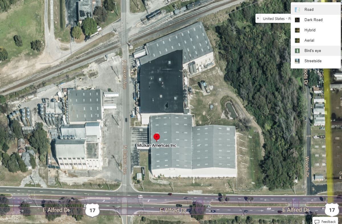
While Google Maps and Google Earth are both excellent tools, I beleive their data both comes mostly from the same source. Don't forget about Bing Maps! I surprised that most folks don't ever mention or think much about recommending Bing maps as a resource. I believe that Bing uses both satellite imagery (like Google maps), but they also use very high resolution aerial images to create Bird's eye and Hybrid images.
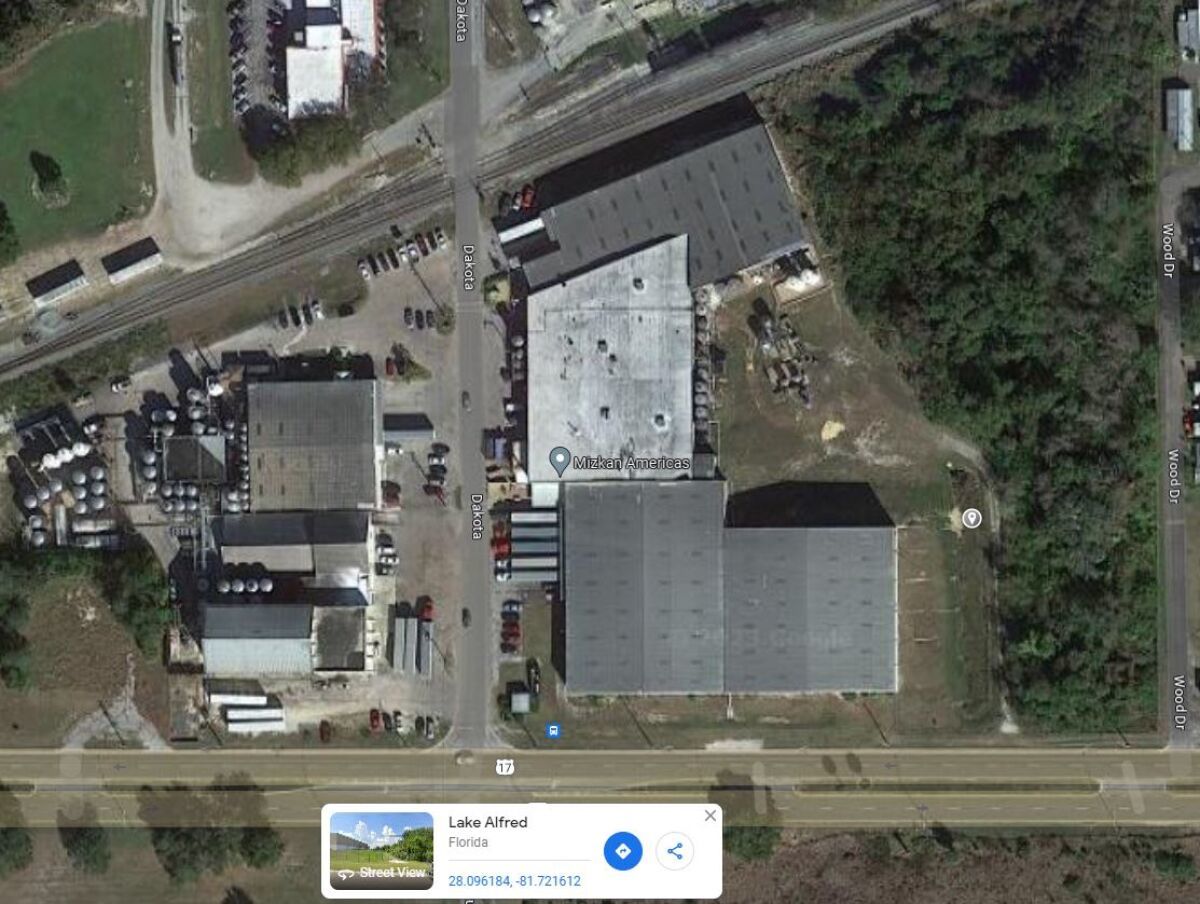
For example, I pulled up a spot near where I live that has some pretty tight backing on their busy days. Mizkan Americas in Lake Alfred, FL. I picked up a load of vinegar from this place once going to a Walmart DC up near Jacksonville. Was quite a challenge for me as a rookie in training, if anybody is interested I will share how my trainer had me handle this one.
Here is the screen shot that most of you will be familiar with from Google Maps.
And here is the Bird's Eye view of the same location from Bing Maps.
Same location in Bing Maps rotated and zoomed a bit to show the loading docks better.
RJ, good suggestion about Bing. I’m going to check it out. Thanks
Bada bada Bing! Lol
Google Maps and Google Earth use different map data at least some of the time. I demonstrated this once before when someone wrote about a difficult Dollar General location that had been remodeled and the Google Maps image was out of date while Google Earth showed the post-remodel image. I guess it's best to check multiple sources if going to a location you're uncertain about as well as check Google reviews for the location since drivers sometimes add photos to their reviews.
I did...no dice. :(
try checking the "reviews" of the company on Google. Some drivers will post photos and what to expect at the place.
I love reading the driver reviews. Some are very helpful and you can find a lot of info you wouldn't otherwise know, like receiving door is by dock 19 etc.
Had the exact same issue with that damn lying mirror during my test as well!
I agree about the set-up being the most important. It took me almost a year before I felt comfortable with what I was doing.
Patience is also super important. Easy to get stressed by the moment and situation and I found myself rushing until got more comfortable with taking my time.
Relates back to my school days for this. I had gotten great at all the manuevers they had us doing in the yard. Offsets, Straight backs(duh), and especially, the blind side parallel park in the box.....Every time in practicing the moves.
Come test day, I, and 5 others got the head instructor, by chance. When it came to our parking stuff, after the in cab, and walk around. So, I was 1st of 2nd doing the manuevers. Well, when it came time for the blind side parallel, I get set up and begin the backing in......I get in almost fully, BUT, in my passenger mirror, I think I am going to be out of bounds, and am going to pull up and try to "fix it"
The instructor, yells, for me to stop, set the brakes and get out, and walk over to him at the bench, with the others. Then he says " Ok, you can TRY and fix it, BUT you will fail, OT you can take a 10 point hit, and pass!".....Of course, he is probably right, so YEAH gimme the 10 point hit,and a pass! Was the only points I'd gotten, so far, so duhhhh I'll take to 90 v.s. a probable fail..
After that the next 2 people, get into the same problem, and given, and take the same option as he offered me.....
New Reply:
New! Check out our help videos for a better understanding of our forum features





Preview:




 TT On Facebook
While Google Maps and Google Earth are both excellent tools, I beleive their data both comes mostly from the same source. Don't forget about Bing Maps! I surprised that most folks don't ever mention or think much about recommending Bing maps as a resource. I believe that Bing uses both satellite imagery (like Google maps), but they also use very high resolution aerial images to create Bird's eye and Hybrid images.
For example, I pulled up a spot near where I live that has some pretty tight backing on their busy days. Mizkan Americas in Lake Alfred, FL. I picked up a load of vinegar from this place once going to a Walmart DC up near Jacksonville. Was quite a challenge for me as a rookie in training, if anybody is interested I will share how my trainer had me handle this one.
Here is the screen shot that most of you will be familiar with from Google Maps.
And here is the Bird's Eye view of the same location from Bing Maps.
Same location in Bing Maps rotated and zoomed a bit to show the loading docks better.