

A New Truckers App From TT: What Would You Like To See?
Topic 33764 | Page 6

How about navigation with avoid weigh stations? j/k!!!
If possible, when you look up a customer on the navigation part of the app one would assume you are integrating with Google Maps like Trucker Path?? It would be awesome also to have a link to Google Earth to see the property you are going to. Countless times I have seen signs from the street view that were God-Sends (Receiving, Shipping, Directions for Freight specific deliveries like pulp or scrap paper etc.)
Thanks Brett!

one would assume you are integrating with Google Maps like Trucker Path?? It would be awesome also to have a link to Google Earth to see the property you are going to
Yap, I'm using Google Maps, and you will certainly be able to pull up street view, satellite view, or map view of any location. I'm assuming Google Earth has the same type of setup I can tap into, and if so, I will have that, too.
Everything will be the simplest commands:
"directions to 25 Consumer Square, Plattsburgh, NY"
"show me a satellite view of 1703 Airport Hwy, Toledo, OH"
"find grocery stores near me"
"what's the forecast for this area?"
"what's the weather in Fort Wayne, IN?"
That's it. That's all you'll have to do most of the time. Just give a very short explanation of what you want, and I'll make it magically appear.

Speaking of casinos, I very briefly stopped at one today (well, the rest area adjacent to it) that Rob has mentioned before, Diamond Jo on 35 in Northwood, IA. I rolled on but would stay there as it was in a rest area. I called another in Columbus, MN, to ask if they allow it, and they said only if you're staying at their hotel. So that's something to be aware of.
Ok, sorry I haven't updated you guys on this app. I'm working on it full time, but I haven't released anything yet because I want it to have certain features before releasing it. I'm working on it full-time.
I want to know what you guys use for GPS. I know Google Maps is popular, and so is Garmin's GPS, especially the trucker-specific one.
Let me know what you guys use for GPS and:
1. Are there features you wish your GPS had that are lacking?
2. Do you do anything to customize your GPS, like adding comments, favorite locations, or custom markings to the maps?
3. What do you do to handle the final mile? Do you mark up the maps in some way? Use sticky notes on your dash?
Thanks!

I use Google Maps for long-distance trip planning, zeroing in on interstate routes first; however, Google Maps no longer easily identifies, at least on my device, the interstates. What I’d like to see is that familiar blue interstate symbol with the interstate number.
2. I’ve customized my Google Map by populating it with hearts; every time I drive past an unofficial or ‘off-the-record’ parking area, I quickly pull up Google Maps, locate the parking area, and save it with a heart and label it “parking.”
3. For the final mile I’ll use a combination of company-provided navi directions, sometimes Google Maps, and whenever provided, specific directions to delivery site provided in the work assignment. And at times I’ll just call my contact if I’m still unsure. I’ll use sheets of paper; I write big, sticky notes are just too small.
Interstate:
Commercial trade, business, movement of goods or money, or transportation from one state to another, regulated by the Federal Department Of Transportation (DOT).
Pete, that's exactly the kind of answer I was hoping for. In other words, not much has changed in 20+ years. It takes a variety of tools and tricks to get the job done. That's why I'm building this app. Now we have the ability to build far more sophisticated tools than ever before.
While I'm thinking about it, I also want to know what you guys do to track the weather along your route. I'm tied into weather systems, so I can give forecasts, alerts, and all kinds of stuff. How do you guys track weather alerts, chain requirements, wind advisories, etc?
My process is similar to what Pete B does.
I liked his suggestion #2. That’s really clever and I’m going to try that idea.
My main GPS is the program loaded on the company Omnitrac, CoPilot Truck. Pretty good program and I’ve learned it well over time. I suspect it’s kind of a dinosaur compared to other programs, but it’s what I’m used to and keeps me (mostly) out of trouble.Takes a real long time to boot up and if I have to enter a destination change along the way, it takes a long time to display the change. Knowing this, I have learned to plan ahead when I fire it up so it can be booted up when I’m ready to roll. I don’t know if that is the CoPilot program or the Omnitrac fault. But sometimes I have to sit somewhere and let it make a route change. Not a huge problem, more like an irritation.
I don’t have a Garmin device. I make extensive use of Google Maps on my IPad. The satellite view is what I use before, during and after every assignment. In my opinion, it’s one of the wonders of the trip planning world.
Like Pete, I still write things down on paper and I make a full size page of info for every assignment. All the pertinent info I will need, bol number and any other number attached to the individual assignment, plus fuel stops and mileage numbers that I want to keep track of. The Omnitrac is tethered to the truck so we can’t bring it into a shipping/receiving office, hence the beauty of writing things down in a notebook.
Those 3 things are my trifecta of navigation.
For weather, I use OnTheWay, Highway Weather and the National weather service. Laura has a very comprehensive collection of useful apps that she has posted a screenshot of. Her list is where I got my apps from. Thankyou, Laura!
HOS:
Hours Of Service
HOS refers to the logbook hours of service regulations.OWI:
Operating While Intoxicated

I use a garmin otr500. I run maps and truckerpath on a 12 inch tablet concurrently.
If I'm going state highways and us highway system, about 60 percent of my travel, unknown routes I check on Rand McNallys motor carriers atlas.
Problem with truckerpath is that it looks cartoonish. It's difficult to make enroute changes and little to no voice command. Maps integrates well with Google assistant. And it's satellite images are the bar for the industry.
I use Google maps mostly as a track map. It's like having a layout of the race track when you are racing on a heads up display, tells you which direction curves, etc. Particularly in new areas in the mountains. One issue is that it won't stay centered on screen on the tablet because I have large font selected. (Getting older sucks lol)
I'd really like to see the oddball hole in the wall truck stops, parking areas and definitely which damn gate to enter and exit at a shipper all in an easy to use and reroute, re select on the fly while in motion package.
Shipper:
The customer who is shipping the freight. This is where the driver will pick up a load and then deliver it to the receiver or consignee.
OTR:
Over The Road
OTR driving normally means you'll be hauling freight to various customers throughout your company's hauling region. It often entails being gone from home for two to three weeks at a time.
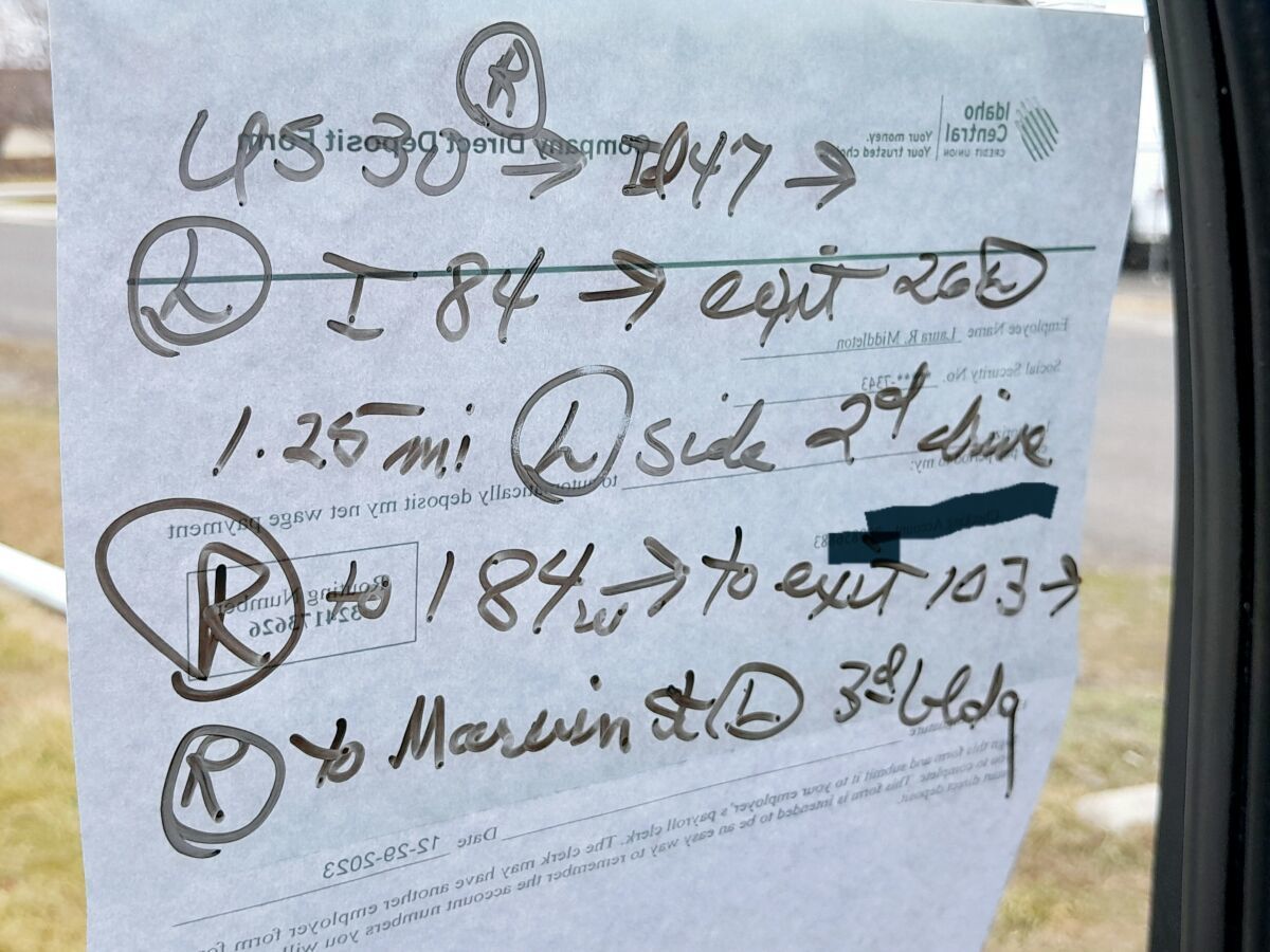
The paper on the outside of the window is to show what I wrote on the window. The camera really didn't see it without the paper there. When I'm going into a new place that has a lot of weird directions according to my Garmin, Google maps and my Atlas, I figure out the best route and write it on the window with those dry erase markers. When I'm done with the trip then I easily erase it.
I use my Garmin GPS. I did like my brother's older Rand McNally, but it took a dump and I couldn't get it fixed. I also use Trucker Path and Google maps as well as my Atlas. I use the states 511 apps that I run through a lot. Now that I am with this new company, I have to add more 511 apps.
This last trip with ATVs and side by sides or whatever you call them, the whole trailer only had 14,000 on it. Monday night Wyoming posted winds at 55+ mph, so I parked it. It was 40 plus mph yesterday going across Wyoming. A wind speed and direction app would have been nice to have. I'll have to look some up.
You are very welcome Bruce. Our PeopleNet has that pilot navigation thing on the ELD. I accidentally hit the navigation button and that female's voice just drove me nuts and I couldn't find a way to turn her down. After I got to my first drop, I went exploring and was able to change it to a male voice and turn it down. I really didn't like the directions that it came up with to Idaho Falls. This is my stomping grounds and I know different roads that can make the trip quicker or shorter and it kept wanting me to make a bunch of turns that were not even truck friendly.
Laura
HOS:
Hours Of Service
HOS refers to the logbook hours of service regulations.New Reply:
New! Check out our help videos for a better understanding of our forum features


Preview:


Why Join Trucking Truth?
- The High Road Training Program
- The High Road Article Series
- The Friendliest Trucker's Forum Ever!
- Email Updates When New Articles Are Posted
Apply For Paid CDL Training Through TruckingTruth
Did you know you can fill out one quick form here on TruckingTruth and apply to several companies at once for paid CDL training? Seriously! The application only takes one minute. You will speak with recruiters today. There is no obligation whatsoever. Learn more and apply here:
 TT On Facebook
I regularly hit up casinos on some routes. 7 arrows on 40 in nm. Couple on us75 69 in OK. There's a couple of abandoned truck stops I love too on 70 and 40.
Currently parked at a lowes DC. I do that regularly. I usually favor sams over wallyworld because we deliver to Sam's so it's normal to see a knight truck there. Plus there bathroom at recieving is open from 4am to 11 pm. I also hit up lowes stores and home sleazepot. Although not that much because they are usually bad for entry.
I have a lot of smaller shippers and recievers I park at even if I'm not delivering to them.
I hardly ever park at loves and j, etc. Just grab a shower on my break in the am. They're over crowded and I love old school truck stops.
I think it could tie in nicely to good sattlelite image and nav for final mile on wallyworld parking. It's one reason why I rarely park at em, it's difficult to map out entry and egress safely.
Shipper:
The customer who is shipping the freight. This is where the driver will pick up a load and then deliver it to the receiver or consignee.