A New Truckers App From TT: What Would You Like To See?
Topic 33764 | Page 7
I use a combination of the things already mentioned. I put the address into my Garmin OTR710DezlCam which doubles as a dashcam. I look at Google Maps and confirm with the atlas. I look at final-mile directions if included in the Workflow, sometimes their great, other times not so much. I write my chosen route on a post-it. If my chosen route differs from what my gps says while underway, I'll go my chosen route then later check into the gps's route to see if that would be a better route in the future.
OTR:
Over The Road
OTR driving normally means you'll be hauling freight to various customers throughout your company's hauling region. It often entails being gone from home for two to three weeks at a time.
Doubles:
Refers to pulling two trailers at the same time, otherwise known as "pups" or "pup trailers" because they're only about 28 feet long. However there are some states that allow doubles that are each 48 feet in length.
HOS:
Hours Of Service
HOS refers to the logbook hours of service regulations.Thank you so much guys for giving me that information. I really need it, and appreciate it.
Problem with truckerpath is that it looks cartoonish. It's difficult to make enroute changes and little to no voice command. Maps integrates well with Google assistant. And it's satellite images are the bar for the industry.
That is all great news for me. I'm going to look into voice commands. I think it's doable. I'd love to make this app voice-controlled. If it can be done, I can do it. I have to see if they allow it or not, and that's up to the folks at Apple and Google.
I can integrate map, satellite, or terrain imagery for the map with light or dark mode. I can integrate street view and satellite view for the customers, as well. I can give multiple routing options, re-routing around traffic backups, and all kinds of stuff. Much more to come on this.
I'd really like to see the oddball hole in the wall truck stops, parking areas and definitely which damn gate to enter and exit at a shipper all in an easy to use and reroute, re select on the fly while in motion package.
I love all that.
With regard to parking, I definitely want to build a massive database of parking locations of every sort, from the Bellagio in Vegas to a muddy pull-off outside a factory in rural Arkansas. If you can park a truck there, I want it in our system. That was one thing that drove me nuts over the years. Anytime I needed to park and couldn't find a spot, I knew there were 20 places within a mile of me where you could park a truck, but they weren't documented anywhere. That just drove me crazy. We can fix that.
Re-routing on the fly is a biggie. The trick is finding an alternative route that is truck-friendly. Google Maps doesn't have a truck-friendly feature built in that I'm aware of, so this will take some exploring. But re-routing is high on the priority list.
Monday night Wyoming posted winds at 55+ mph, so I parked it. It was 40 plus mph yesterday going across Wyoming. A wind speed and direction app would have been nice to have. I'll have to look some up.
I have a national weather service built-in with real-time alerts nationwide for your route. It contains literally every kind of alert there is, including coastal flooding, ice buildup, high winds, thunderstorms, snowstorms, etc. Everything. I will send all alerts for your route and keep you updated on any changes as they come in.
Here's another question: do you guys use a dedicated GPS, your phone, or an iPad mounted on your dash for navigation? I expect most people use their phones or a dedicated GPS because it might be difficult to mount an iPad where you can see it well.
Shipper:
The customer who is shipping the freight. This is where the driver will pick up a load and then deliver it to the receiver or consignee.
Here's another question: do you guys use a dedicated GPS, your phone, or an iPad mounted on your dash for navigation? I expect most people use their phones or a dedicated GPS because it might be difficult to mount an iPad where you can see it well.
Right now I'm using my Garmin...have to update it, but it's never updated completely before it stops
My last company used TransFlo for paperwork and as their ELD. It was awkward seeing it on my phone and it caused me to worry when I had to hold my phone to shake it so it would go from portrait to horizontal so I could see my drive hours.
When I am home in 10 days, I'm going to see if I can download Rand McNally or Garmin GPS on that tablet so I could use it. I bought a large window mount but being a standard size tablet I had to rest it on the dash
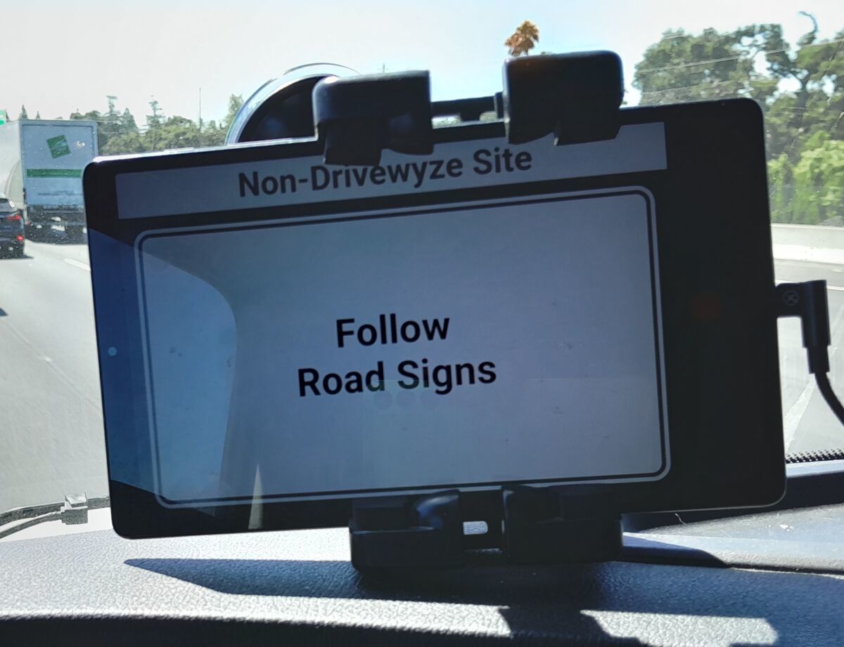
I do like that size and it did not interfere with my hood mirrors or anything. New Mexico pulled me in for a Level I and the inspector saw it mounted on the dash as he stood on my steps. I was able to take it off the mount and hand it to him so he could get my logs sent to himself.
Laura
I use a dedicated, truck driver GPS.
A couple things that pop into mind that I would find helpful.
1. How far away is the next weigh station on my route?
2. How far away is the next rest area?... How far away is the one after the next one?... if I skip the next rest area or there is no open parking spots... I think to myself, can I wait until I get to the next one or should I bail the interstate and hit a truck stop instead if I have to use the restroom? If I know how far that next rest area will be I can make that decision more effectively.
3. Distance to the next exit or next truck friendly exit would be nice as well.
My ELD and Garmin GPS would typically give a heads up when approaching the next weigh station, but the alerts are hit or miss. Consistent and obvious alerts for these as well as other approaching things would be nice to have.
Interstate:
Commercial trade, business, movement of goods or money, or transportation from one state to another, regulated by the Federal Department Of Transportation (DOT).
Laura, I also use a dry erase marker on my upper windshield in case GPS fails en route.
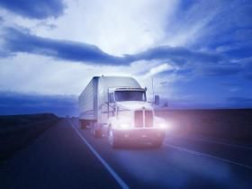
The paper on the outside of the window is to show what I wrote on the window. The camera really didn't see it without the paper there. When I'm going into a new place that has a lot of weird directions according to my Garmin, Google maps and my Atlas, I figure out the best route and write it on the window with those dry erase markers. When I'm done with the trip then I easily erase it.
I use my Garmin GPS. I did like my brother's older Rand McNally, but it took a dump and I couldn't get it fixed. I also use Trucker Path and Google maps as well as my Atlas. I use the states 511 apps that I run through a lot. Now that I am with this new company, I have to add more 511 apps.
This last trip with ATVs and side by sides or whatever you call them, the whole trailer only had 14,000 on it. Monday night Wyoming posted winds at 55+ mph, so I parked it. It was 40 plus mph yesterday going across Wyoming. A wind speed and direction app would have been nice to have. I'll have to look some up.
You are very welcome Bruce. Our PeopleNet has that pilot navigation thing on the ELD. I accidentally hit the navigation button and that female's voice just drove me nuts and I couldn't find a way to turn her down. After I got to my first drop, I went exploring and was able to change it to a male voice and turn it down. I really didn't like the directions that it came up with to Idaho Falls. This is my stomping grounds and I know different roads that can make the trip quicker or shorter and it kept wanting me to make a bunch of turns that were not even truck friendly.
Laura
Hey Laura, I also use a dry erase marker but have stopped writing on my driver door window because when I lower the window it erases the writing. Do you have this problem? Or do you just never open your window, lol ?
HOS:
Hours Of Service
HOS refers to the logbook hours of service regulations.
Hey Laura, I also use a dry erase marker but have stopped writing on my driver door window because when I lower the window it erases the writing. Do you have this problem? Or do you just never open your window, lol ?
When I came back on the road in 2014, I was driving a 2012 international. The windows did not seat tightly in the door, so when I wrote on the window and opened it, it usually didn't get erased. Then I went into Freightliners and drove them until last month when I got put in this Peterbilt. I have written on the windows and when opened, the writing does get erased. However, I don't open the window while I'm driving, mainly only when I am backing up.
On this load that I picked up in Baker City OR, I dropped down to Ontario OR and then ran US95 north to Grangeville ID. I stopped to visit a Facebook goat friend for the first time. I was telling her of my route that I had planned to take out of Grangeville. I was going to go cross country to come out at Missoula Mt on I-90. The route that I had so painstakingly wrote on the window, she told me that it had a number of areas that were dirt road and with the snow recently having melted off, I could end up in trouble. She gave me a different route which was a good road. So I opened the window before I took off and closed it, wiping off most of the dry erase pen. 😉😂🤣
Laura
A couple things that pop into mind that I would find helpful.
1. How far away is the next weigh station on my route?
2. How far away is the next rest area?... How far away is the one after the next one?... if I skip the next rest area or there is no open parking spots... I think to myself, can I wait until I get to the next one or should I bail the interstate and hit a truck stop instead if I have to use the restroom? If I know how far that next rest area will be I can make that decision more effectively.
3. Distance to the next exit or next truck friendly exit would be nice as well.
My ELD and Garmin GPS would typically give a heads up when approaching the next weigh station, but the alerts are hit or miss. Consistent and obvious alerts for these as well as other approaching things would be nice to have.
All of that will be in the app. I will have truck stops, rest areas, and weigh stations in the system. I believe I may create settings for 'alerts' that will allow you to customize which alerts you receive, including things like weather, traffic, and upcoming locations.
Interstate:
Commercial trade, business, movement of goods or money, or transportation from one state to another, regulated by the Federal Department Of Transportation (DOT).
New Reply:
New! Check out our help videos for a better understanding of our forum features


Preview:




 TT On Facebook
I have 2 gps’s that I fight with.
Truck installed is garmin based, but outdated. The system does not have enough memory to update it.
Rand McNally 550 does ok about 80% of the time. I always look at what they say and bounce that against the paper atlas.
I started out using a stenobook writing down all mt trip info and still use it today. If it’s a customer I know well it’s abbreviated. Pencil and paper rarely fail, unlike any electonic format.
I use the weather service app and with tracking it sends me alerts.